




Putting Texas History on the Map with a Location-Aware Mobile App

In Brief
A Mobile App Connecting Travelers with History Across Texas
The Texas Historical Commission (THC) preserves and promotes historical markers, museums, and heritage sites across a state where history can be found around nearly every corner. The agency wanted to make those places and their stories easier for residents and visitors to discover while traveling, extending access beyond its existing online resource.
Resource Data developed Texas History Navigator, a location-aware mobile app that now connects users with more than 18,000 historical markers and sites across Texas. With nearby discovery, trip planning, check-ins, and more features, the app gives people a more interactive way to find, visit, and experience Texas history.
Key Takeaways
Turning Texas History into a Mobile Experience
-
Extending THC’s reach beyond the web
Resource Data developed Texas History Navigator, an app to make THC’s historical information easier to access while people travel and explore Texas.
-
18,000+ historical places accessible on the go
The app brings information for more than 18,000 historical markers and sites into a single mobile experience, making Texas history easier to access wherever people travel.
-
Location-aware discovery connects history to place
Geolocation helps travelers uncover historical places around them and learn about the stories connected to where they are.
-
Turning historical discovery into real-world journeys
Trip planning helps people move from finding an interesting place to visiting it, making it easier to build historical destinations into trips across Texas.
-
Encouraging continued exploration across the state
Check-ins, points, levels, and badges give visitors a way to track their progress and set new goals, encouraging them to keep discovering Texas history.

Meet Our Client
Texas Historical Commission
The Texas Historical Commission (THC) is the state agency responsible for preserving and promoting Texas history. Based in Austin, the agency works to protect and promote historical markers, museums, heritage sites, and other places that connect residents and visitors with the state’s past.
With thousands of historical places spread across Texas, THC also helps make information about those sites accessible to the public, supporting education, preservation, and heritage tourism.

The Challenge
Historical Information Designed for the Web, Not the Road
The Texas Historical Commission already maintained information about historical locations online, but accessing that information was not designed around how people encounter history in the real world. Travelers could pass a historical marker on the road or visit a new part of the state without an easy way to learn what happened there, why the place mattered, or what other historical sites were nearby.
With markers, museums, and heritage sites spread across a state as large as Texas, THC saw an opportunity to bring that information directly to residents and visitors wherever they were. The agency needed a mobile experience that could use location data to connect people with nearby history, make thousands of sites easier to explore, and support its broader goal of increasing public awareness and engagement with Texas history.
The Solution
An App for Discovering Texas History on the Go
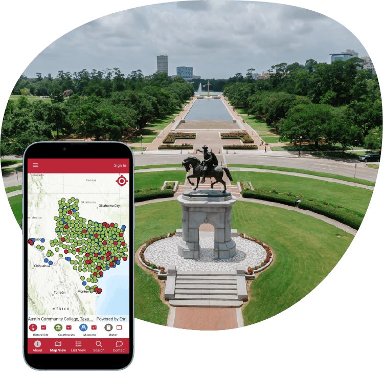
Resource Data developed Texas History Navigator as a mobile experience built around where users are and where they want to go. The app connects THC’s historical information with geolocation and an ArcGIS Online interactive map, allowing residents and visitors to search thousands of historical markers, museums, and heritage sites, see what is nearby, and learn more as they travel.
As THC looked for new ways to encourage exploration, the app expanded beyond location-based discovery. Resource Data added user accounts, check-ins, points, levels, and badges that let users track the places they visit and progress as they explore more of the state. Plan My Trip also allows users to select multiple destinations, arrange their stops, and continue the route in Google Maps or Apple Maps.
Features
From Geolocation to Navigation: Technology Behind the App
-
Location-Based Discovery for Exploring Nearby History
Geolocation connects visitors with historical markers, museums, and heritage sites near their current location, while an ArcGIS Online map provides a visual way to search and explore sites.
-
Plan My Trip Building Multi-Stop Routes
Locations selected from the in-app map can be added to a trip, reordered, and sent to Google Maps on Android or Apple Maps on iOS for turn-by-turn navigation.
-
Proximity-Based Check-Ins for Tracking Visits
Check-ins use a defined geographic range to verify that someone is near a historical site before awarding its assigned point value. Points accumulate on the user’s account and contribute to level progression.
-
Achievement Badges for Encouraging Exploration
A separate badge system recognizes users for meeting specific visit criteria. Available achievements and earned badges are displayed in the app, creating additional goals beyond accumulating points.
-
Live Data Integration for Keeping Site Information Current
The app connects to THC-managed data through its API, allowing changes to details such as site information to flow into the mobile experience while THC maintains control of the source data.
-
Text-to-Speech Accessible Historical Content
Google text-to-speech functionality converts written historical content into audio, allowing visitors to tap the speaker option and listen to site information directly in the app.


The goal was to give people access to this information while they’re out exploring Texas. When you see a historical marker along the road, the app gives you the context behind it and helps you discover what’s nearby.
- Chris Fry, Technical Lead, Resource Data

Results
Texas History, Ready to Explore
Texas History Navigator has made more than 18,000 historical markers and sites accessible through a single mobile experience, giving residents and visitors a new way to connect with Texas history wherever their travels take them. Instead of relying on an online resource before or after a trip, people can discover the stories connected to the places around them while they are there.
The app also helps turn that discovery into real-world exploration. Travelers can uncover destinations they might otherwise pass by, create historical journeys for themselves, friends, or family, and access stories in written or audio form along the way. For THC, the result is a new channel for bringing its historical resources beyond the website and into the places and experiences they document.

What's Next
Bringing History Even Closer
THC continues to explore ways to connect travelers with the history around them through Texas History Navigator. One potential future enhancement is proximity-based notifications that could alert users when they are near a historical site, helping them discover places they may not have known were along their route.
As the app continues to grow, future enhancements can build on the same goal that shaped the original project: making Texas history easier to discover and experience wherever people travel.