




911 Addressing Solution Expedites Address Allocation
In Brief
Easy data collection tool for quality results and streamlined processes
Cities and counties nationwide rely on accurate 911 response and addressing systems to ensure emergency responders know exactly where to go. When a midsize city in Texas was down to a single GIS staff member, a significant backlog of critical 911 addressing requests accumulated.
By implementing Esri’s Survey 123 and Experience Builder, Resource Data’s GIS experts addressed the backlog and streamlined the request submission and management processes. Address processing times were cut by 50%. These new tools not only improved the City’s operational workflows but also simplified the process for public users who now submit 90% of their requests online.
Key Takeaways
Faster, more accurate address processing
-
Simple, cost- and time-saving solution
With Esri’s Survey 123 and ArcGIS Experience Builder, the City has a cost-effective solution with a platform they already know. Address processing times were reduced by 50%, saving valuable time.
-
More transparency and easy access to information
Using the Survey 123 form for addressing requests makes it easier for public users to see what information they need to provide. With automatic confirmation of submissions and a tracking number, they’re confident their requests were received.
-
Improved workflows and reduced processing times
A searchable Experience Builder portal replaced time-intensive Excel spreadsheets and gave the City’s GIS department better insight into request statuses and volumes.
-
Tracking critical information in one place
The system automatically flags missing details like access points and deeds, making it easier to identify outstanding requirements. It allows for status updates, enhancing the City’s ability to manage, search, and review requests.

The Challenges
Voicemails, emails, and spreadsheets to collect and process critical requests
The City serves as the county seat, boasting a population of around 125,000. Addresses are crucial for various purposes, including emergency response, utility services, mail delivery by the USPS, as well as zoning and planning. Previously, residents and business owners would request addresses via phone calls, voicemails, and emails. Then the City’s GIS team assigned the appropriate number and street name, and added a point address for a more precise location.
Delays from incomplete information and limited process visibility
Address designation was often hampered by customers providing insufficient details, requiring several calls to collect more information. In addition, the City’s GIS staff manually input and managed information in Excel spreadsheets.
These methods were time consuming, inefficient, and prone to errors. This approach also had limited visibility and lacked insights, leading to requests potentially being overlooked or delayed. The City needed a better way to collect and process information and easily track customer interactions.
The Solution
Simple solutions, big impacts
Facing a severe GIS staff shortage and growing backlog of critical 911 addressing tasks, the City’s Chief Information Officer (CIO) and Director of Information Technology—and former Resource Data client while serving as CIO at the Anchorage Water and Wastewater Utility—turned to us for assistance. He hoped we could not only alleviate the existing backlog but also implement technology solutions for process improvement.
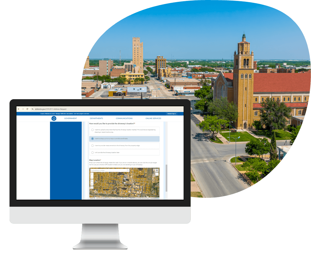
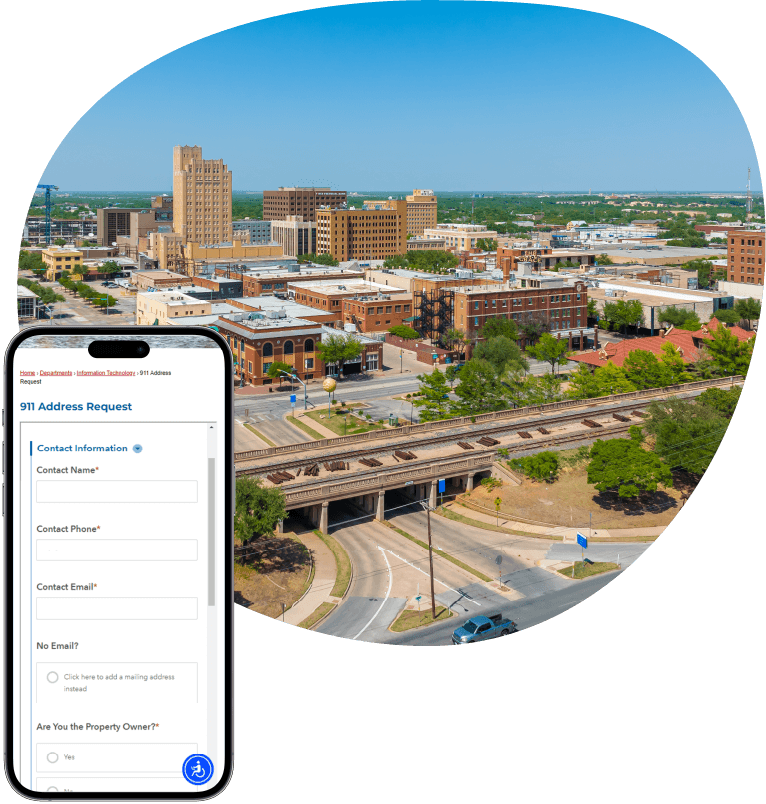
Our GIS team prioritized the backlog of urgent requests before creating a more efficient system for managing 911 addressing requests. With existing Esri licenses, we developed a cost-effective solution using Esri’s Survey 123 and ArcGIS Experience Builder. The Survey 123 online form lets citizens submit requests on the City’s website. The form makes it easy to see what initial information is required and they receive a confirmation ticket number.
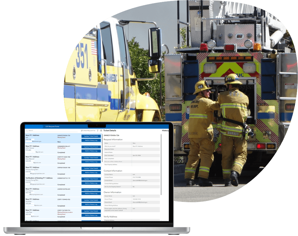
We replaced Excel spreadsheets with a searchable Experience Builder portal, giving the GIS department better control over request status and volumes. The system also automatically flags missing details like access points and deeds, making it easier to identify outstanding requirements. And statuses enhance the City’s ability to manage, search, and review requests.
Features
Streamlined data collection and processing, increased transparency, and optimized workflows with Esri solutions
-
User-friendly form for easy submission and transparency
The online Survey 123 form makes it easy for customers to submit requests at any time. Each request is confirmed upon submission and automatically receives a ticket number for tracking and better customer service.
-
Form prompts for complete information and shorter response times
When certain answers are selected, the form generates related questions. This prompts customers to provide more complete information and reduces the need for follow-up.
-
Enhanced filter for simple searching
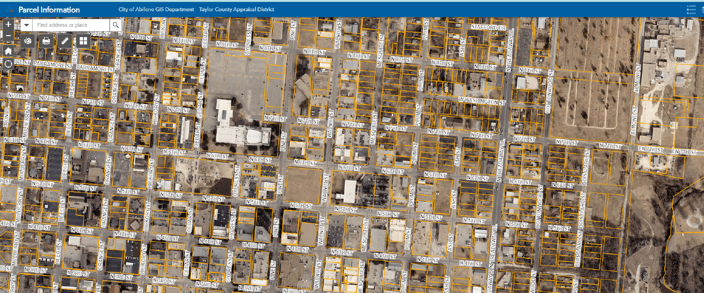
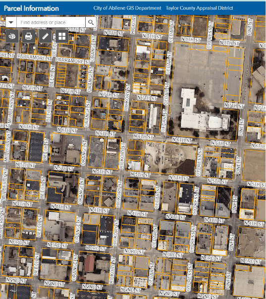
Users easily find relevant address information by searching or filtering with name, ticket number, email, new address, date, status, and request type. Location data is easy to view on maps by using property ID or nearest neighbor’s address.
-
Automated flags for identifying missing information
The automated system flags missing information so it’s easy to pinpoint what’s still needed and resolve issues. Statuses such as complete, in progress, waiting for requestor response, or waiting for clearance, can be assigned by staff.
-
Time stamps and history log for better tracking
Within the Experience Builder portal, City and County departments can track where customers are in the addressing-assignment process. This improves communications and makes it easier to assist customers.
-
Integrated systems for accurate data
Experience Builder integrates with other City and County systems like CAD, Parcel data for the County, and MyGov, ensuring address and point data is up to date and accurate—this is crucial for routing first responders correctly in emergencies.
Resource Data quickly stabilized our operations, modernized our workflows, and delivered innovative GIS solutions that made a clear, measurable difference in public service, safety, and efficiency. I strongly recommend Resource Data as a highly qualified vendor to provide IT and GIS services.
- Sharla Allison, Division Manager, Abilene/Taylor County 9-1-1 District
Results
Processing time cut in half
The additional GIS staff and new tools Resource Data provided have streamlined workflows, increased transparency, and reduced address processing times by 50%. The previous turnaround time averaged one week, and now averages two days.
Now 90% of requests are received through the Survey 123 form, with limited requests submitted via voicemail. This has made it easier for the City and County to track requests, and requests are far less likely to get lost in emails.

What's Next
Ongoing partnership
We continue working with the City to support their addressing system. Part of this work is ensuring the information they collect meets NENA 911 standards, which includes national guidelines for 911addressing.
With Resource Data’s GIS expertise, the City can pursue other GIS projects, such as establishing data standards, improving data structures, and cleaning up data. Our team also plans to support integrating GIS technologies across the City and develop dashboards for more accessible ways to view key stats related to initiatives.




Case Study FAQ
A city can speed up 911 address assignment by simplifying intake, standardizing the information collected up front, and moving request management out of disconnected emails, voicemails, and spreadsheets into a single tracked workflow. In many municipalities, the delay is not caused by the actual logic of assigning an address. It comes from chasing missing information, sorting through scattered requests, and updating records manually in systems that do not give staff a clear picture of what is waiting, what is incomplete, and what is ready to move forward.
That matters even more when staffing is limited. A small GIS team cannot afford to spend most of its time triaging intake problems instead of completing addressing work. A better process reduces unnecessary follow-up and gives staff a faster path from request submission to address allocation.
In Resource Data’s case study, a midsize Texas city had accumulated a significant backlog of critical 911 addressing requests while operating with only one GIS staff member. Resource Data addressed the urgent backlog and then implemented a Survey123 form and Experience Builder workflow to streamline intake and management. This case study demonstrates that even a small GIS team can improve turnaround dramatically when the intake and tracking process is modernized.
They create delays because those channels rarely force requestors to provide complete, consistent information the first time. When requests come in through phone calls, voicemails, or email, staff often have to interpret the request, figure out what details are missing, follow up for clarification, and then enter the information into a separate tracking process. That turns a straightforward public service task into a repetitive administrative one.
This becomes especially problematic in 911 addressing because accuracy matters, and the request often depends on details like access points, deeds, property references, or nearby addresses. If those pieces are missing, staff cannot move the request forward safely or confidently. There’s more back and forth, delay, and risk that requests get overlooked.
In Resource Data’s case study, residents and business owners submitted requests by phone, voicemail, and email. Then, city GIS staff assigned the number and street name manually and managed the work in Excel. Many requests arrived with insufficient details, which required several follow-up calls. In this case study, informal intake channels created avoidable bottlenecks in 911 addressing. This led to slower processing, more staff effort, and a greater chance that important requests would be delayed or missed.
A city needs to collect enough location and property details at the start, so staff can evaluate the request without multiple rounds of follow-up. In practice, that usually means making sure the requestor provides the right identifiers, relevant ownership or deed information, access details, and enough geographic context to determine the proper address point and street assignment. The exact data requirements may vary by jurisdiction, but the underlying principle is consistent: the form should guide people into giving staff what they need the first time.
Incomplete intake does not just slow response. It can also create confusion around parcel location, access, and emergency routing. A stronger intake process helps requestors understand what is required and gives the city a more reliable basis for addressing assignments.
In Resource Data’s case study, the new system flagged missing details such as access points and deeds automatically, and the Survey123 form prompted related follow-up questions based on certain answers. That made it easier for users to submit more complete information and reduced the need for extra calls. Resource Data’s example demonstrates that better intake design improves speed and quality.
A city can make the process easier by giving the public a guided online request form that clearly shows what information is required and confirms that the request has been received. Most residents and business owners are not experts in addressing workflows. They simply want to know what to submit, whether the city got it, and how to track what happens next. If the process depends on guesswork or informal contact, people are more likely to leave out important information or feel uncertain about whether their request is moving forward.
A guided form solves several problems at once. It reduces confusion, improves submission quality, and gives users more confidence that they are following the correct process. It also creates a more transparent experience for people who may be requesting an address for construction, utilities, mail delivery, zoning, or emergency access.
In Resource Data’s case study, the online Survey123 form made it easy for customers to submit requests at any time. They could also see what information was needed and receive an automatic confirmation with a tracking ticket number. This case study shows how a better public facing process improves customer experience as well as internal efficiency. The operational impact is more complete submissions, less customer uncertainty, and a smoother request experience for the public.
A searchable portal is better because it turns request tracking into an active workflow rather than a passive recordkeeping exercise. Spreadsheets can store data, but they are not well suited for managing changing statuses, outstanding requirements, history logs, and multiple search paths across a growing request queue. As the number of requests rises, spreadsheets become harder to maintain accurately and harder for staff to use as a real time operational tool.
A portal gives the GIS department much better visibility into what is happening. Staff can search by customer name, ticket number, email, address, date, status, or request type and quickly understand what still needs attention. That kind of visibility is what helps prevent requests from getting buried or delayed.
In Resource Data’s case study, Experience Builder replaced time intensive Excel spreadsheets with a searchable portal that improved the GIS department’s control over request status and volumes. Staff could search and filter by multiple fields and view location data on a map using property ID or a nearby address. In this case study, moving from spreadsheets to a workflow portal improved tracking and accountability. The city gained better visibility, faster searching, and fewer lost or overlooked requests.
Local governments can reduce incomplete or stalled requests by pushing more validation to the front of the process instead of relying on staff to discover missing information later. That usually means using a smart intake form that adjusts its questions based on earlier answers and using automated flags to identify what is still missing before staff begin full review. The goal is not to create more complexity for the user. It is to create the right amount of guidance so the user submits a request that staff can act on.
This approach works because most delays happen before the addressing logic begins, when the city does not yet have enough information to proceed. A form that prompts for the right details and a system that flags missing elements can reduce those early bottlenecks significantly.
In Resource Data’s case study, the Survey123 form generated related questions when certain answers were selected, helping customers provide more complete information. The system also flagged missing details such as access points and deeds so staff could see what was still needed. This case study demonstrates that automated completeness checks can reduce stalled requests without adding more staff overhead.
A better 911 addressing workflow improves public safety because accurate address assignment helps ensure first responders can be routed to the correct place quickly. Addressing is not only an administrative function. It affects emergency dispatch, public utilities, mail delivery, and planning. If addresses are delayed, inaccurate, or not tied to the right point of location clearly, the effects can reach beyond inconvenience and into emergency response risk.
That is why addressing systems need speed and accuracy. A city cannot treat 911 addressing a simple clerical queue. The workflow has to produce reliable location information that other critical systems can trust. When the process is better structured, the city is in a stronger position to support safe routing and faster response.
In Resource Data’s case study, the solution integrated with City and County systems such as CAD, parcel data, and MyGov to help address and point data stay current and accurate. The case study notes that this is crucial for routing first responders correctly in emergencies. In this case study, modernized addressing workflows strengthen public safety as well as internal operations.
The most useful status tracking is the kind that shows where each request sits in the process, what information is still missing, and who is waiting on whom. In a municipal workflow, it is not enough to know that a request exists. Staff need to know whether it is complete, in progress, waiting for requestor response, waiting for clearance, or fully complete. Those distinctions make it easier for different departments to coordinate and respond appropriately when customers ask for updates.
A visible history log also matters because it helps staff understand what has already happened with the request. That improves continuity, reduces duplicated effort, and makes it easier for the city and county users to assist the public without having to reconstruct the case manually.
In Resource Data’s case study, the Experience Builder portal allowed statuses such as complete, in progress, waiting for requestor response, and waiting for clearance. It also included time stamps and a history log for better tracking. City and County departments could see where customers were in the process and communicate more clearly. This example shows that better internal status tracking creates more consistent service across departments.
A city can improve transparency by confirming each submission automatically, assigning a tracking number, and making the workflow easier for staff to monitor and explain. For many customers, one of the most frustrating parts of a request process is not knowing whether the city received their request or whether it is stalled somewhere in the system. Transparency reduces that uncertainty and helps set more realistic expectations.
This is especially important when the process supports time-sensitive needs such as construction, utility activation, or emergency preparedness. A customer who receives confirmation and knows there is a trackable record is much less likely to feel lost in the process. Internally, that transparency also makes it easier for staff to answer questions without digging through emails or voicemails.
In Resource Data’s case study, the online form automatically confirmed submissions and generated a ticket number for tracking, which lets customers know their requests had been received. The new tools also gave City and County staff more visibility into status and volume. This Resource Data case study demonstrates that transparency is a meaningful service improvement. The operational impact is better customer confidence, fewer duplicate inquiries, and smoother communication throughout the process.
A modern 911 addressing solution creates long-term value by giving a city a stronger operational foundation for standards, cleaner data, better integrations, and future GIS improvements. Clearing the backlog is important, but the bigger opportunity is to replace a fragile, manual process with a sustainable system that can support public safety, planning, and service delivery over time.
That long-term value often includes better compliance with addressing standards, improved data structures, and a stronger platform for additional GIS projects or dashboards. Once the city has a more organized way to collect and manage request data, it becomes easier to improve reporting, data quality, and cross department visibility in the future.
In Resource Data’s case study, Resource Data continued supporting the city after implementation. This work included helping to ensure the information collected meets NENA 911 standards and supporting broader efforts around data standards, improved data structures, data cleanup, and dashboards. This case study demonstrates that a good addressing solution does more than solve an immediate process problem. Results include stronger long-term data quality, better standards alignment, and a more future ready GIS environment.