
A Unified Air Quality System Delivers Near Real-Time Data Alerts
In Brief
New Platform Protects Public Health with Faster Air Quality Alerts
Air quality monitoring plays a vital role in protecting public health, especially in regions with heavy industrial activity. For the Texas Commission on Environmental Quality (TCEQ), serving over 25 million Texans, outdated technology and disconnected dashboards delayed vital public alerts.
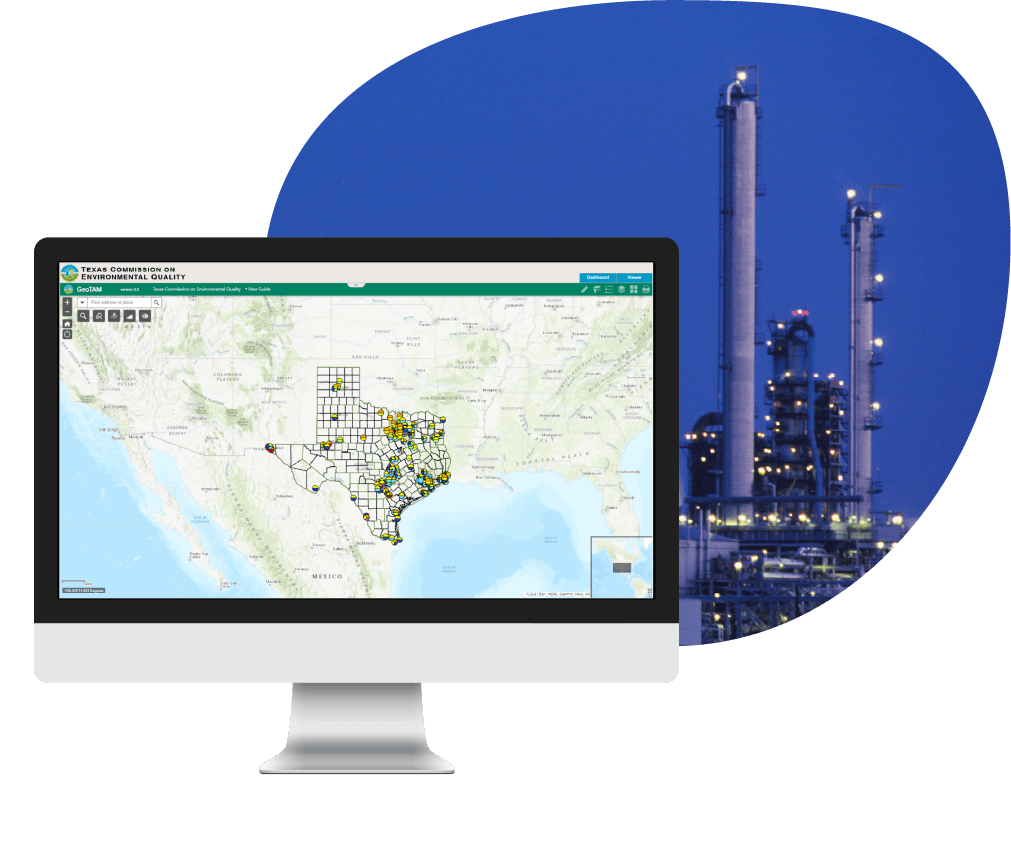
The new GeoTAM, built on Esri’s ArcGIS Experience Builder, replaced the legacy system with a single, unified application. The platform gives Texas communities near real-time access to environmental updates and reduces data latency from 24 hours to just 15 minutes.
Key Takeaways
Smarter Monitoring. Faster alerts.Stronger transparency.
-
Unified platform simplifies access to statewide data
By combining mapping and dashboard functions into a single interface, the public can easily visualize air quality data to identify unsafe conditions and researchers can run reports and track trends more efficiently.
-
Air Quality data latency reduced by 99%
The application reduced air quality refresh rates from every 24 hours to 15 minutes, enabling faster public alerts and stronger protection during hazardous events.
-
Historical records enable long-term research and compliance
GeoTAM contains records back to 2010, including information from decommissioned stations. This creates a comprehensive resource for long-term studies and regulatory reporting.
-
Transparent visualizations strengthen public trust
Updated mapping and visualization tools display accurate ambient air monitoring data in clear, accessible formats. By making risks easier to understand, TCEQ strengthens public trust and awareness in its reporting.
-
Configurable design enables future expansion
GeoTAM is a low-code application with built-in flexibility to expand into other environmental monitoring areas, such as water quality.

Our Client
TCEQ: Safeguarding Texas Air and Public Health
With over 2,800 employees, the Texas Commission on Environmental Quality (TCEQ) leads the state’s efforts to safeguard public health and natural resources through clean air, clean water, and safe waste management.
Within TCEQ, the Air Monitoring Division (AMD) operates one of the nation’s largest air monitoring networks, operating more than 200 monitoring stations spread across Texas’ vast 268,000 square miles. These stations collect critical data from areas with heavy industrial activity, such as refineries and chemical plants. AMD ensures accurate collection, analysis, and public reporting of air quality data, meeting federal reporting requirements while keeping communities informed.

Challenges
Outdated tools risked delayed alerts and limited awareness
The original Geographic Texas Air Monitoring (GeoTAM) system gave geospatial views of air quality data, but its technology had reached its limits. Built on Esri’s ArcGIS Web AppBuilder, scheduled for retirement in 2026, it lacked real-time data integration, a unified interface, and intuitive navigation.
Because the viewer and dashboard pulled separately from the Texas Air Monitoring Information System (TAMIS), staff and the public had to toggle between platforms to assemble a complete picture. Map visualizations offered only limited pollutant values, threshold levels, and monitoring locations, slowing analysis and communication.
Without modernization, TCEQ risked delayed reporting, incomplete datasets, and unreliable alerts during hazardous events—jeopardizing both public safety and trust.

The Solution
GeoTAM: A Unified System for Real-Time Air Quality Data
The new GeoTAM modernized TCEQ’s statewide monitoring system by unifying dashboards and maps into one application built on Esri’s ArcGIS Experience Builder. The system connects directly to the Texas Air Monitoring Information System (TAMIS), integrating data from more than 200 monitoring stations into a single interface.
Through this platform, the public, researchers, and TCEQ staff can access near real-time pollutant levels, compare values against thresholds, and explore historical records dating back to 2010.
This modernization gave TCEQ a unified, sustainable system that better protects public health, improves workflows, and prepares for future extension into other areas of environmental monitoring.
Features
Designed for clarity. Built for impact.
-
Interactive station pop-ups for detailed insights
Each monitoring station is clickable, displaying pollutant-specific values, thresholds, and site details. This transparency supports staff in communicating findings and helps the public understand localized air conditions.
-
Customizable multi-layered maps for easier exploration
Configurable map layers allow pollutant filtering, threshold comparisons, and updates without external support. Communities and staff can tailor views to focus on the regions and pollutants most relevant to their needs.
-
Historical records for stronger long-term analysis
With data going back to 2010, including decommissioned stations, GeoTAM creates a comprehensive record. Researchers and policymakers gain insights into long-term patterns to guide planning, compliance, and health protections.
-
Built-in guides for usability and adoption
Step-by-step user and application guides make the platform easy to navigate for both the public and staff. These resources reduce training time and ensure broad accessibility across diverse Texas communities.

Results
Faster Insights Build Public Trust and Safer Communities
The new GeoTAM delivers a single, unified platform for exploring and interpreting Texas air quality data. For the public and researchers, it provides a transparent, self-service experience that reduces reliance on manual requests and custom reports. For staff, it ensures a sustainable, streamlined system that supports long-term operations.
A significant breakthrough is the dramatic reduction in data latency—from 24 hours to just 15 minutes, a ~99% improvement. This near real-time reporting allows for faster public alerts and supports better awareness during environmental hazards.

What's Next
Scaling momentum across the organization
TCEQ can apply the same unified solution to other areas of environmental monitoring and build on the success of the new GeoTAM. With Esri’s ArcGIS Experience Builder already in place, they can easily replicate and adapt the platform for water quality and waste management insights when ready.